
A novel approach to remote sensing time series analysis has been introduced, promising to revolutionize environmental monitoring and urban planning. The review, published in the Journal of Remote Sensing on December 11, 2024, presents an innovative methodology that integrates multi-source data to enable near real-time monitoring of terrestrial changes.
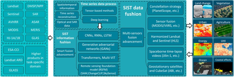
An international research team from South China Normal University, the University of Connecticut, and the Chinese Academy of Sciences has developed this advanced technique, which combines deep learning algorithms with traditional remote sensing methods. The new approach addresses key challenges in remote sensing, such as incomplete data and noise interference, by leveraging Long Short-Term Memory (LSTM) networks and Generative Adversarial Networks (GANs).
This breakthrough has significant implications for various fields, including agriculture, urban development, and environmental management. The enhanced accuracy and reliability of the data obtained through this method could play a crucial role in addressing global challenges such as climate change and sustainable development. Professor Fu, an expert in the field, emphasized the method's potential to transform our ability to monitor environmental changes.
The methodology's future applications are vast, particularly in global environmental monitoring and supporting sustainable development goals. By integrating multi-temporal data from Landsat and Sentinel-2 satellites, the team has created a framework for accurate and continuous terrestrial analysis. As computational power advances and algorithms improve, this technology is expected to become a vital tool for natural resource management, disaster response, and climate change mitigation.
The importance of this development cannot be overstated. As urbanization accelerates and environmental dynamics shift, the need for accurate and timely terrestrial monitoring has become increasingly urgent. This new technique offers policymakers and researchers a powerful tool to gather critical data for addressing pressing environmental issues on a global scale. The ability to extract subtle patterns from large, complex datasets and generate synthetic data to fill gaps in observations represents a significant leap forward in remote sensing capabilities.
As the world grapples with the challenges of climate change and rapid urbanization, this innovative remote sensing technique stands poised to provide the detailed, real-time environmental data necessary for informed decision-making and effective conservation efforts. Its potential to enhance our understanding of Earth's ecosystems and urban landscapes could prove invaluable in shaping sustainable policies and practices for years to come.